

‘AN EARLY MORNING WALK IS A BLESSING FOR THE WHOLE DAY’- HENRY DAVID THOREAU
Wise words Thoreau, although I certainly took a while to warm up to this fact when tackling Table Mountain via the India Venster route. Slightly sleep-deprived and a little worse for wear, I set off later than planned, willing the cloud engulfing the mountain’s flat top to evaporate into the otherwise clear blue sky. No chance. When I arrived at the cable station for a last ditch attempt to fuel up with caffeine, I was informed that the cable was currently not running due to winds. I watched several people head up the nearby trail by foot regardless. I decided to do the same, with the prospect of having to walk down negated by the mountain forecast showing settled conditions with passing cloud until the afternoon. It would be open before I knew it, right?
Cape Town offers an array of hiking options on its doorstep allowing for an outdoor lifestyle with the perks of city life. Lion’s Head and Table Mountain are two popular iconic peaks which can easily be accessed from the city. I also hiked Devil’s Peak thanks to my friend’s recommendation and was not disappointed. It is worth hiking at least one of these peaks for the views, nature and glimpse into a lifestyle some Capetonian’s are lucky to experience. After all, it is not often you can be on a mountain top in the morning, at the beach in the afternoon and dancing in the city by evening.
My favourite hike was Devil’s Peak. Read about my experiences below.
table mountain
lions head
devils peak
General points
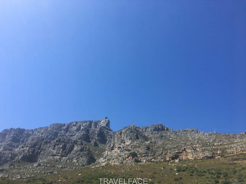
Table Mountain
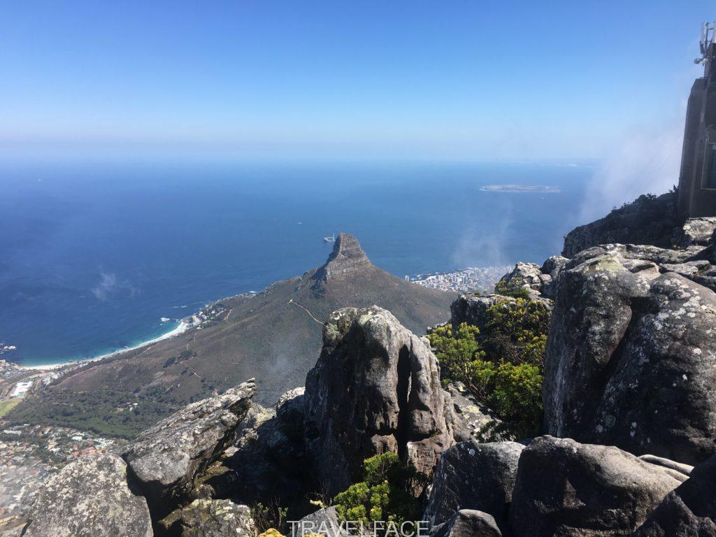
And so I walked. 9am and the sun was already beating down as I trudged up the stone stepped path under the cable car above, until it joined the contour path. I had quickly saved an aerial map of the route but did not have to worry. You simply walk behind the sign at this intersection to be greeted with painted yellow footprints and arrows which continue up the entirety of the India Venster route (although I did have a few frantic moments struggling to locate the next footprint). Soon any weariness gave way to awe at the views below, as I stopped to rest after some initial scrambling. Lion’s Head and the city were framed by the rocks around me; a rare respite from the sun and moment to absorb the silence.
I passed several people coming down; some solo, some couples. No-one mentioned the elephant in the room: the lively cloud which continued to shield the summit from view. I decided to keep going.
After following the path that curves round the mountain for views of Clifton below, the wind suddenly hit me, blowing my sunglasses and calmness away. Luckily I retrieved my sunglasses but it took a little longer to be calm again. My friend from home expressed concern by text as I was hiking alone, and pointed out the afternoon forecast of more cloud. By this point I was over halfway and spent a few frantic breaths panicking on a tricky scramble. Retreating on this route downhill in changing weather did not entice me. Continuing on won.
I am used to hiking in adverse weather conditions in the UK, and had packed accordingly. Despite the now dewy mist cooling my sun beaten body, it was relatively sheltered, visible and calm. I was alone, had passed most of the scrambling and had not seen anyone for some time, what I personally liked.
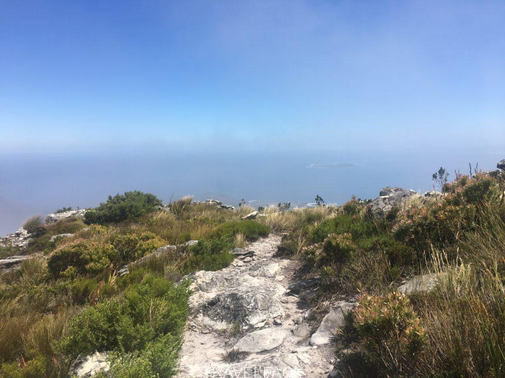
Two local friends knew where I was and were checking in. I must admit I may have gripped the loaned pepper spray in my pocket for a while after the message from my friend, who had jolted me out of my peaceful isolation. Prepared or unprepared (this is down to debate), but once I reached the deserted top of Table Mountain and the cloud broke I knew I had made the right choice for me.
Soaked by this point from the dew filled clouds I passed through, I spent some time marvelling at glimpses of Cape Town below. It felt slightly bizarre having the summit to myself, with everything shut up and the cable car still. Once I headed back via the more commonly used Platteklip Gorge I met many people heading up. All with the same questions of course: ‘How far to go?’, and, ‘is the cafe open?’ Many were in shorts, with no spare layers. I even saw a few pairs of flip flops and gave one of my 2 litre water bottles to a young family who had already run out of water. This made me feel slightly more prepared as I realised how many people probably visit this top tourist must-see without any idea of what they are undertaking.
Eventful though my hike may have been, I returned to the city refreshed for the day, with the spark of adventure a little stronger, and a renewed appreciation for the powerful mountain that presides over the Mother City.
- Get there: Uber, citysightseeing bus or public bus. Limited parking. Free shuttle 110 service from Kloof Nek Road.
- Time: 5 hours there and back. Average times 2-4 hours one way.
- Height: 3,583ft.
- Why do it? Its Cape Town’s main landmark, high views, different routes with varied traffic, and the cable car allows access for all.
- Fun fact: It is over 260 million years old!
common routes:
Platteklip Gorge- most commonly used, direct option up to the summit meaning crowds & less views. easiest way to descend, although still watch your step as it can be STRENUOUS. start by the cable station or there is a start point further along tafelberg road.
india venster- do not take this route lightly. some scrambling required, with the odd chain/rung for assistance. marked but pay attention. with a good fitness level and hiking experience (ideally scrambling also), this route is doable and rewarding. start by the cable station. I’D RECOMMEND THIS WAY IF POSSIBLE. Useful information here.
skeleton gorge– start in kirstenbosch gardens.
cable car- take the cable car one way or both. expect queues. up to date rates here.
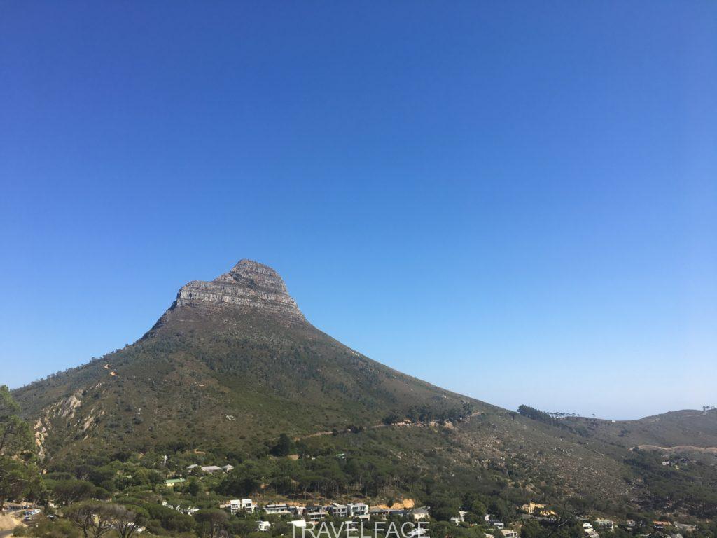
Lion’s Head
It was my first peak and what an introduction to the spiritual mountains of Cape Town.
Another prominent landmark in its own right, Lion’s Head is many people’s favourite climb, thanks to the all-encompassing views. It is well-marked and can be completed in a quicker time than Table Mountain. Many opt for a sunset hike with a beer at the top as a result. Or if you time it right, try a full moon hike. Trail running is also popular as the sun rises, and you may spot a paraglider or two.
We walked up and down in two hours, but started later than our intended sunrise hike. Coincidentally we were greeted by many others who had also thought it was a good idea to hike on this sunny Saturday morning. Funny that!
During ascent we avoided the metal rungs due to the queue and heat. The alternative way added a few minutes to the hike and was signposted. We used the rungs on descent, where I attempted to shimmy down them as casually as possible but failed miserably. Despite the crowds we found a quiet spot to sit and take in the vast views at the top before heading down and enjoying a coffee from the vendor. Table Mountain, the Twelve Apostles, white sand beaches, the stadium and city below are just some of the highlights to admire and orientate to from above, making it a perfect start or end activity during a trip to Cape Town.
- Get there: Uber, drive (limited spaces, most park along the road).
- Time: 2- 3 hours including time at the top.
- Height: 2,195ft.
- Why do it? An accessible climb for those with basic fitness. Great views. The perfect spot for sunset.
- Fun fact: Yes, records show there were once lions occupying this mountain.
route:
there is one route up and down. you can avoid the ladder rungs by following the signposted recommended route at this point. The rungs only mark a fraction of the hike.
Devil’s Peak
It dawned on me that perhaps I was not on the most direct route up to Devil’s Peak when I had to grab a large stick to navigate through the overgrowth and make myself heard to the scuttling sounds coming from it. It’s just a lizard. It’s just a lizard. I muttered to myself as I smacked the ground and shuffled through.
The Uber driver had insisted there was no where else to drop me asides from the entrance to Plattekip Gorge along Tafelberg road (trust your gut kids). I saw a signpost for Devil’s Peak at an intersection when I headed down this route, so did not think much of this. So I slowly began on the switchbacks and waved him off into the distance with a 5 star rating.
After departing the Table Mountain path alone at the signpost as others continued up, I realised how far Devil’s Peak was. I was going to have to tackle the saddle before even reaching the direct trail up. I kicked myself for giving a 5 star rating and not checking the route options more closely. The undisturbed look of the trail and hum of life suddenly made sense.
After some time furiously shuffling with stick in hand, and bandana on, I stopped to rest in a sheltered cave overlooking the city and coast below. A colourful palette of red, yellow and purple flora surrounded me. My only companions were the chattering of wildlife and rising sun. Time to breathe in the wild.
Let go.
I switched to classical music to mix up my Rambo vibe; thanks to the stick, wide snake-searching eyes, bandana and foliage in my hair that had somehow gone unnoticed. And so I kept walking, embracing the isolation and accepting that my plan of a 4 hour return hike may not be met.
I must admit it was a relief to lose the stick once I met the trail intersection of more commonly used trails, following the sign for Devil’s Peak. Another reminder that civilisation was not too far away was meeting two hikers on their way down from summiting, who informed me I was the first person they had seen, so I too was likely to have some time at the summit on my own.
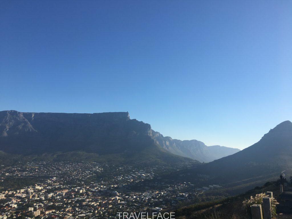
It was evident attempts had been made to structure the steep and at times loose gravelled path up to Devil’s Peak. Flora richly grew around the clear path, unlike the covered snake-infested trail further back. There were plenty of excuses to stop and admire the views (aka catch my breath). Table Mountain stared back at me with a visible summit and crawling cable cars, a world away from the peace of Devil’s Peak. Creeping clouds passed below between the two peaks, flowing from one side of the ocean to the other, temporarily shading the land from the African sun.
I was temporarily deceived when I reached the first bouldered lookout area, thinking it was the top. In fact there was at least ten more minutes of walking for my tired legs. It was worth it. I climbed over various rocks to sit by the peak beacon and admire the 360 degree views, graced with only a slight breeze and visibility which stretched to the mountain and ocean hued horizons. My last weekend in Cape Town was upon me. This was the perfect peak to reflect, prepare for mountain withdrawal, absorb the city, and capture its surroundings as much as possible before my return home.
I headed back down the signposted Tafelberg road route. It felt like I was walking directly into the ocean with Robben Island in view. Then the path sloped downwards and the city reared its head, reminding me of its proximity to this outdoor haven. My last taste of the wild was having to wait 30 minutes for an Uber by the roadside Devil’s Peak sign, before I was driven back to the centre for a weekend of farewells to the Mother City (until next time anyway).
- Get there: *For Tafelberg road route* Park in the small lay-by car park just beyond Plattekip Gorge’s start point. There is a sign for Devil’s peak on the right-hand side. If you have reached the barrier you have gone too far. Alternatively taxi to this.
You can also get public transport to the cable car then follow the contour path that links all the way to Plattekip gorge and passes India Venster’s trail. Head down the switchbacks and look out for the Devil’s Peak sign at the intersection. If unsure walk along Tafelberg road until you reach the Devils Peak sign.
For my way, start at Plattekip Gorge’s sign on Tafelberg road. Devils Peak’s trail will be to the left when you reach the intersection. - Time: 3-5 hours dependable on start point and fitness level.
- Height: 3,281 ft
- Why do it? No crowds, the best views in all directions (in my opinion), admire all the endemic flora around this area.
- Fun fact: Devil‘s Peak is named after the folk-tale about a smoking contest between a Dutch man and the devil, which formed the cloud cover over the mountain.
common Routes:
Tafelberg Road: Look out for the Devil’s Peak sign. This route can be steep and windy at times.
Mowbray Bridge: Starting at Rhode’s Memorial. Advised for experienced hikers due to sharp drop offs and scrambling.
Newlands Ravine: Also starting at Rhode’s Memorial and through newlands forest.
General points
- You can do all three peaks and include Signal Hill in one challenging day!
- Judge your fitness level. You can take the cable car up Table Mountain. In my opinion Lion’s head (avoiding the metal rungs) is the easiest hike. Plattekip Gorge is steep and slippery especially if it has rained, but many people complete this route. If you want to try India Venster but are not confident, go with a guide.
- Respect the mountain. Weather can change quickly, and wind speeds can get dangerous on exposed areas. Check the mountain forecast, but come prepared for the unexpected.
- If the weather does change and makes it difficult to continue, swallow your pride and return. Heed this advice if you still have scrambling to do on the India Venster route.
- Do not panic if you cannot see the yellow markers on the India Venster. Pause and scan. Retrace your route slowly if possible. Alternatively head to a safe point where you can easily look in both directions for one.
- Essentials: A waterproof/windbreaker, hat, a thin pair of gloves, sunscreen, fleece layer, enough water (2 litres per person minimum for Table Mountain and Devils Peak), and snacks. Obviously items will vary slightly dependable on season. Layers are always key.
- I only had running trainers so hiked in these. At times they lacked tread and support needed on descent. Hiking boots would be preferable for me.
- I hiked alone as noted. Obviously it is advisable and safer to hike in groups. There have been incidents on and around Table Mountain. If alone consider a guide. If you do go alone it is important to pack emergency items. Consider a basic first aid kit, pepper spray, a torch, and a way of attracting attention, such as a whistle. Ensure someone local knows your whereabouts and estimated return time.
- Saving emergency numbers is essential (main mountain emergency number- 0861106417).
- Be mindful that phone service can vary, especially on Table Mountain. Ensure your phone is fully charged and take a portable charger for back up.
- Check if the cable car is running if you plan to return this way, and leave enough time to get down.
- Take all rubbish with you and stick to marked paths.
- Look out for wildlife such as the rock hyrax, and watch your step to avoid the rare chance of sunbathing snakes.
useful links
cable car website: https://www.tablemountain.net
cape town tourism website: https://www.capetown.travel/things-to-do/nature/
mountain forecast: https://www.mountain-forecast.com
Read my city guide on Cape Town here.


18 Comments
Beautiful photos and helpful tips. I only knew of table mountain.
Thank you for your comment Sue- I am glad to have been able to give you some helpful information.
Those views are amazing! I would love to visit those peaks!
Yes so amazing !!! When clear anyway haha. I hope you manage to get there!
I have never been to South Africa yet, and this post makes want to book a flight! These views are truly magical 🙂
Go go go!! Yes very much so 🙂 I hope you make it there soon.
I wish you had written this guide before I attempted Table Mountain! We only did the hike up and gondola down but it was hot and we didn’t have enough water – if the cafe at the top hadn’t been open we would have been in trouble! Lions head was much easier for sure!
Ah no I am pleased it worked out for you!! I also found there wasn’t much easily accessible information out there. At least you have this for next time. Definitely!!! Thanks for your comment.
I never made it up to Table Mountain when I was in Capetown! I’ll have to go back, and check out those other hikes as well 🙂
Yes it is an excuse to go back right!? Thank you for your comment, hope you make it back there soon.
Cape Town is so high on my bucket list! And the views from these places must be stunning! Thank you for sharing this tips 😉
You’re welcome, I hope you manage to get there soon!
Wow just wow! Honestly, I had no idea of the peaks in Cape Town, and the view is just gorgeous! You’ve put together such useful info, kudos for that 🙂
Thanks so much, so glad you have found it useful!! Yes gorgeous views all round!
Did the Lion’s Head Mountain in September and it was a beautiful hike
Ah great to hear, glad you also enjoyed it!
Pingback: CITY GUIDE: 2 WEEKS IN CAPE TOWN - travelface
Pingback: EIGHT TIPS FOR HIKING SOLO AS A WOMAN - travelface