

‘mountains have a way of dealing with overconfidence’ – nemann buhl
It is not hard to see why North Wales was part of Lonely Planet’s 2017 ‘Best in travel’ list, and why crowds continue to visit en masse to explore the beautiful region. It is full of adrenaline activities, with Snowdonia National Park playing host to many of them. From Surf Snowdonia and nearby Penrhyn Quarry for the fastest zip-line in the world, to white-water rafting and underground trampolining. Amongst all of this is Mount Snowdon, the third highest mountain in the UK and one of the most accessible, with various hiking routes and a train up to its peak. It is one of my favourite spots in the UK to hike, so below I have outlined route options for hiking Snowdon, along with some other useful information.
Note: Check up to date information about car park closures and other restrictions currently in place (2020).
skip to:
– General information about hiking in snowdonia national park
– PYG TRACK
– LLANBERIS PATH
– MINER’S TRACK
– SNOWDON RANGER PATH
– rhyd ddu path
– WATKINS
– crib coch
pyg track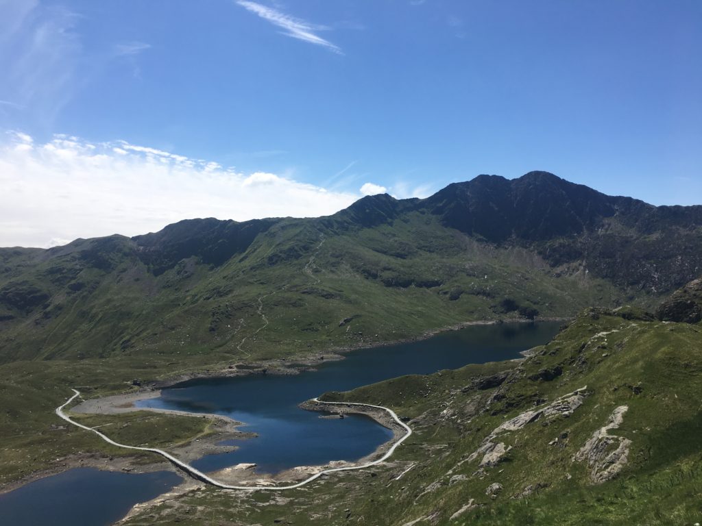
pros: scenic views, quickest, easy to follow
cons: challenging, steep, one of the busiest routes
best combination: up via pyg, down via llanberis, or down via miner’s for a circular route
distance: 5.5km and 800m ascent one way
time: 2-3 hours on average one way
start: pen-y-pass.
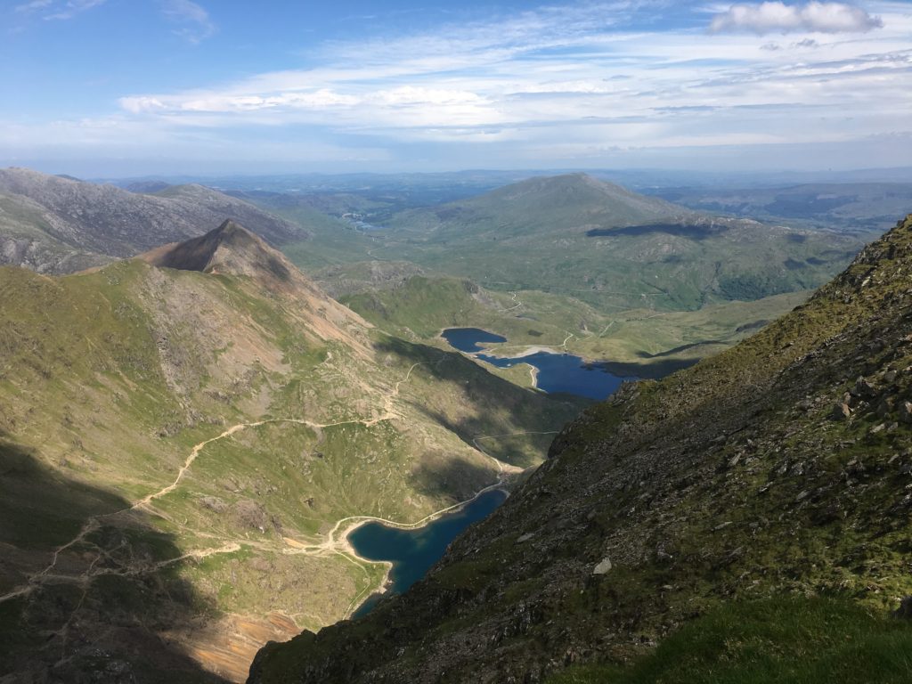
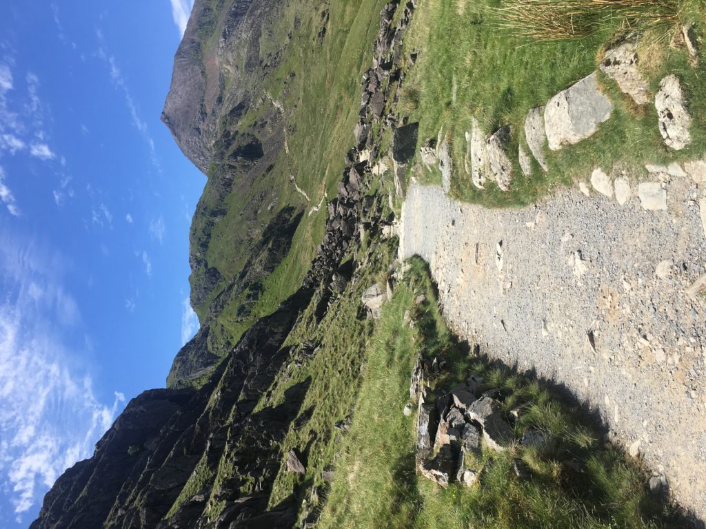
The Pyg track is the Snowdon hiking trail with a quick, and scenic ascent. Initially it is relatively flat, but you are climbing a mountain after all, so soon large stone steps, and a little scrambling will greet you. Once you reach the viewpoint in the above picture, the path again flattens with some inclines and declines which are easily tackled.
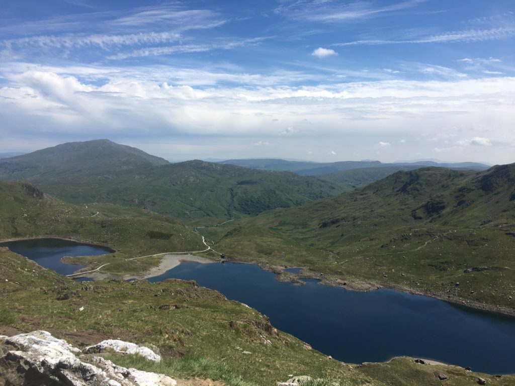
This is the perfect time to capture Lyn Llydaw lake and the smaller lake of Glaslyn. Make the most of this stage before you reach the next steep section where queues tend to build as you realise how popular hiking Snowdon is. This section starts at the beginning of the zigzag path, which takes you to the final stage of your ascent. This is also where you can capture Glaslyn and Snowdon’s summit on a clear day.
Once you join the Llanberis path, head up to your left to the summit marker and enjoy your achievement at the top of Mount Snowdon.
Descent: I tend descend by Llanberis as I often park my car in one of the many car parks here, and catch the ‘Sherpa bus’ for £2.50 to the start of the Pyg track. This takes around 20 minutes.
I do not recommend descending Snowdon via Pyg as it is busy and steep. As an alternative to Llanberis consider the Miner’s path to get back to Pen-Y-Pass car park, making it a circular route.
TIPs: Pen- Y- Pass’s car park is small, so consider catching the Sherpa Bus from one of the other car parks, such as Nant Pass or llanberis village. check car park prices. i usually use the visitor centre car park or Padarn country park car park.
Fun fact: No-one knows why this trail is called ‘Pyg’, but there is more than one theory as to why.
Llanberis path
pros: gradual ascent, easiest route
cons: takes longer to complete, busy
best combination: down via llanberis, combine with ascent via other option to get a variety of views
distance: around 7km and 950m ascent one way
time: 2.5-4 hours on average one way
start: Llanberis town
Do not take this Snowdon hiking trail too lightly, as prior to the final ascent there is a steep section with some loose scree. Unfortunately once we had to wait for some time for an air ambulance to land and evacuate a lady who broke who her leg on this part when descending. I tend to descend this part in a zig zag fashion but if this is not for you just take it slow.
Asides from this section (and the tarmac once you reach the town) Llanberis is one of my favourite descents from Mount Snowdon. Why? You get to different views coming down this side, and it is less harsh on the knees due to the fairly gradual descent.
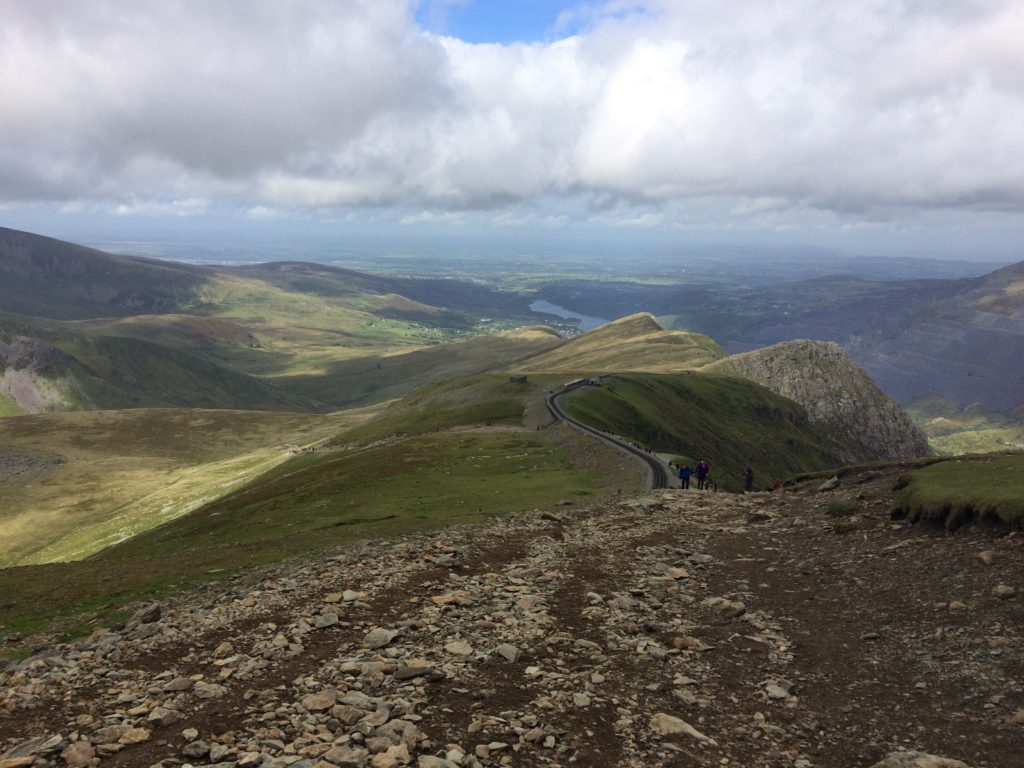
It is an easier route, so opt for this if you are not a confident walker or would like to take the train one way, which also starts in Llanberis. The track follows along a similar route so wave away to the happy passengers who will pass you by. Once you pass the Bwlch Glas stone, and are joined by those who have taken the Pyg route, you know the summit of Snowdon is within sight.
Descent: The same way if possible. Alternatively opt for another route such as Miner’s and get the Sherpa bus back to Llanberis. You can descend via the Pyg route (described above), but as mentioned this is one of the steepest Snowdon hiking trails.
Tip: a good halfway marker is the small cafe you will pass, feel free to stop for a light refreshment.
FUN FACT: WAVING AT THE PASSING TRAIN PASSENGERS IS ALWAYS FUN.
Miner’s track
pros: Take a dip in the lakes, different views
cons: joins the pyg track route anyway, longer
best combination: down via pyg, if you are willing to brave the steep descent. or via Llanberis then get the bus back to pen y pass.
distance: 13km round trip, around 765m ascent
time: 6-8 hours ROUND TRIP
start: pen y pass car park (trail start signposted, like the pyg route)
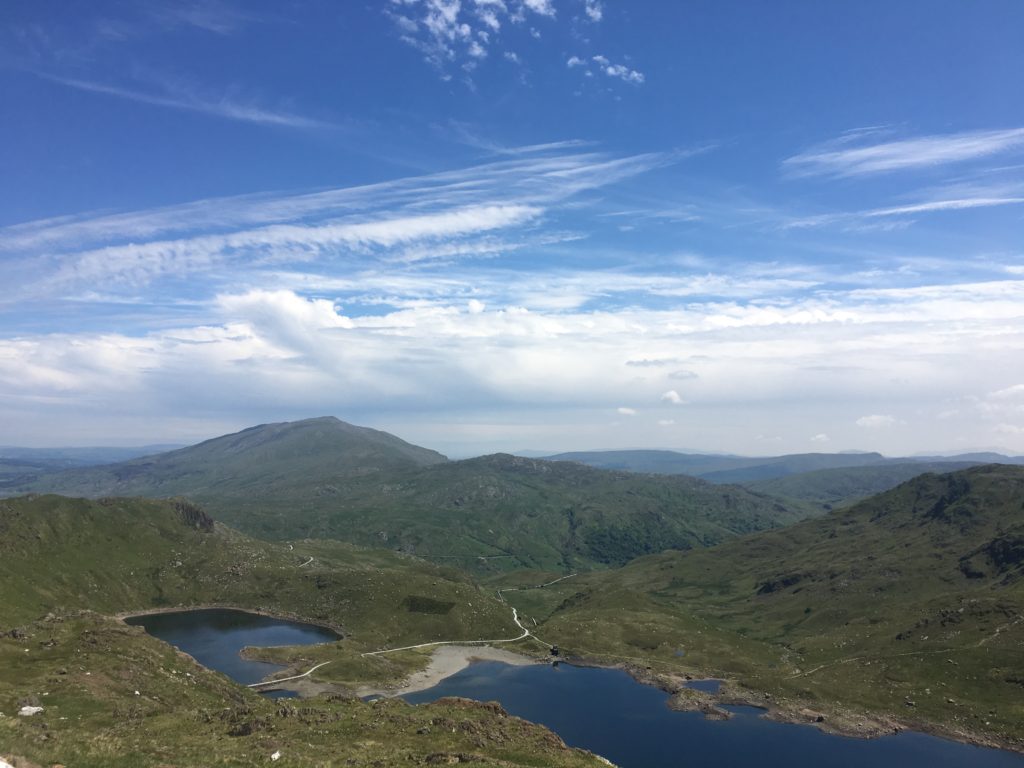
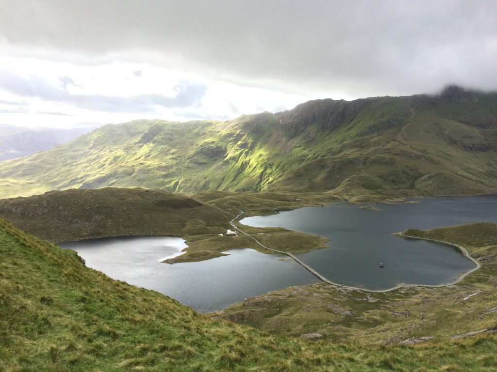
Enjoy a different perspective of Mount Snowdon this way, and walk alongside the lakes- Llyn Teyrn, Lyn Llydaw lake and Lake Glaslyn. Perfect if you want to take a dip on a sunny day, or stop here for a picnic. Some people just hike to here and do not ascend the route to Mount Snowdon.
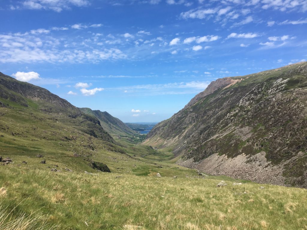
This trail is great to admire the Mount Snowdon’s horseshoe, look back at Nant Gwynant valley, and spot old miner barracks. It is a longer hike, so you can ease into it before tackling the ascent.
Once you pass the lakes things get steeper. You will see the path that takes you up to the intersection of the Miners’ and the Pyg Tracks. You will know once you reach this because there is a stone marker. After this the route description is the same as the Pyg track.
Descent: As noted above, descent via Pyg is difficult due to the narrow and busy path. You will be walking against people a lot of the time. If you want to, it is quicker to get back to Pen Y Pass if you walk all the way along the Pyg track.
Alternatively I would recommend LLanberis as it is a wider trail and asides from the initial section of descent, an easier path for the knees. Catch the Sherpa bus back to Pen-Y-Pass if you have parked here.
tip: BRING A BATHING SUIT AND TOWEL IF THE WEATHER PERMITS.
FUN FACT: Copper used to be transported along this way, for Snowdon’s Britannia Copper Mine.
FANCY HIKING SNOWDON AS PART OF THE THREE PEAKS CHALLENGE? READ THIS BLOG POST
snowdon ranger path
pros: quieter option, GRADUAL ASCENT with new start to trail
cons: Less amenities at the start compared to busier llanberis
best combination: Rhyd Ddu, for a horeshoe route.
distance: 6.23km one way, 894m ascent
time: 5-7 hours ROUND TRIP
start: Snowdon Ranger Station car park, LLYN CWELLYN (also serviced by the sherpa bus) or llanberis
I have not personally hiked this route, but this link will be able to provide further detailed information on this hiking route up Snowdon.
This trail starts by following the Snowdon Highland Railway tracks. There is a signpost to direct you before a switch back ascent. This trail also eventually joins the Llanberis, Pyg and Miner Snowdon hiking trails. Starting near the aptly named ‘Snowdon Ranger’ youth hostel, Llyn Cwellyn, this trail also starts with a gradual ascent. Reports are that the new path is also better.
You will get to enjoy views down to Llyn Ffynon Gwas and Nantlle Ridge, along with eventually spotting Mount Snowdon’s summit if weather permits. The mid-section gets steeper up to the top of Clogwyn Du’r Arddu, a trail which is marked by piles of stones. Soon you join the Llanberis hiking route up Snowdon, which you will recognise thanks to the large stone marker (a monolith), and maybe a train chugging past.
Descent: Hikers report combining this route with Rhyd Ddu as a nice option for a horseshoe hike of Mount Snowdon. As always the reliable Sherpa Bus makes travelling between start points relatively easy.
tip: check out the local pub and microbrewery nearby the start- the snowdonia parc inn.
FUN FACT: This trail is named after James Morton, one of Snowdonia National Park’s first guides. So this trail is also one of the oldest!
rhyd ddu path
pros: quieter option, scenic, relatively gentle ascent
cons: steep exposed final section, be careful! path sometimes eroded, but stone piles help guide the way.
best combination: SNOW RANGER PATH, for a horeshoe route or south ridge for a circular route.
distance: 14.5km round trip, 890m ascent
time: 6- 7 hours ROUND TRIP
start: RHYD DDU car park (also serviced by the sherpa bus).
This trail starts relatively well marked but be careful once you reach the trail intersection with at Pen-y-lon. There is a stone to mark the Rhyd Ddu path off to the left, otherwise you will continue up to the South Ridge (another route option if you fancy)!
This trail is fairly old, and at times boggy. You may be able to spot some remaining ruins, and climb over a gate or two if closed. Whilst there is not much scrambling involved, the crossing of Bwlch Main ridge is quite rocky and narrow so watch your step (though not as much as Crib Goch). As expected the route up to this section brings amazing views but it is when the trail is steeper, so feel free to stop for a picture break or two. Once on the ridge a clear day will present the top of Mount Snowdon in all is glory, plus the wonderful surrounding valleys around.
Following the top of Llechog, the views are extensive across to Bwlch Main and the Summit, with one of the best aspects towards the summit of any path.
Descent: Create a horseshoe by descending Mount Snowdon via the Snowdon Ranger Path. An alternative would be to do a circular route by ascending via the South Ridge then returning via Rhyd Ddu .
Option: Go ahead and go up the South Ridge to then join the trail! This is also a lesser known, but highly reviewed route. See this link for more information.
TipS: Taking the train to the start of this walk is highly recommended! OR GET THERE EARLY TO SECURE A PARKING SPOT.
fun fact: It was historically known as the Beddgelert Path, as it originally was a pony path.
also Try hiking in the brecon beacons, wales
WATKINS
pros: STARTING FROM BASICALLY SEA LEVEL SO YOU ARE HIKING ALL OF 1,085M OF SNOWDON! VARIED SCENERY FROM THE WOODS TO WATERFALLS.
cons: (DEPENDABLE ON VIEWPOINT!) STARTING FROM BASICALLY SEA LEVEL SO YOU ARE HIKING ALL OF 1,085M OF SNOWDON! ONE OF THE HARDEST ROUTES SO BE PREPARED.
best combination: SNOWDON SOUTH RIDGE FOR A CIRCULAR WALK.
distance: 6.46km one way, around 1000m ascent
time: 3.5-4.5 hours one way
start: nantgwynant car park
Up for the challenge? Watkins is rated as one of the hardest routes up Snowdon due to the final challenging ascent, with some nice loose scree thrown in at parts for good measure. However enjoy the initial waterfalls of Afon Cwm Llan and Hafod y Llan woods. The path starts opposite the car park over bridges and into the valley of Cwm Llan, at which point you are nearing the waterfalls.
After this you pass a rock making the opening of this route, and also marking the steep ascent. You eventually get to the ridge that you can stop and dare to look over to see the Miners and Pyg track below, and the lakes of Llyn Llydaw and Glaslyn. During this section it is essential you watch your step, and have free hands to use surrounding large rocks for grip. The scree is plentiful and there are lots of loose rocks. However once you pass this you will interect with two other Snowdon hiking routes: Rhyd Ddu and the South Ridge. Head past Snowdon’s cafe and enjoy reaching the summit!
TIP: FOR MORE COMPLICATED ROUTES SUCH AS THIS, IT IS IMPORTANT TO HAVE SOME MOUNTAIN HIKING EXPERIENCE. FAMILIARISE YOURSELF WITH DETAILED DESCRIPTIONS OF THE ROUTE SUCH AS THIS ONE AND TAKE A MAP.
FUN FACT: THIS WAS BRITAIN’S FIRST FOOTPATH, OPENED BY PRIME MINISTER WILLIAM GLADSTONE (HENCE THE ROCK MARKING ITS OPENING).
MORE HIKING blog posts
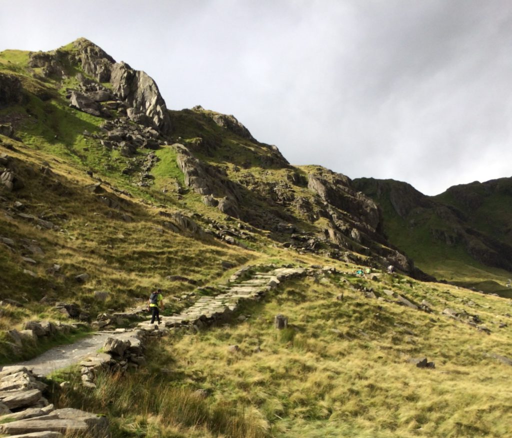
 CRIB COCH
pros: FOR THE EXPERIENCED, A challenging route up mount snowdon
cons: not marked so hard to find the right line up the ridge.
best combination: either back down a route ending at pen-y-pass or take an easier route like llanberis to rest!
distance: around 5.62 km one way, 852m ascent
time: 5-6 hours one way
start: pen-y-pass
Last but not least, hiking Snowdon up this route is not for the inexperienced. This is a Grade 1 scramble and mountain rescue is often called to help people who are stuck.
I have not hiked this route (yet) and because it is a Grade 1 scramble, I feel it is better for an experienced hiker of this route to describe the scramble in detail. Here is a useful route description.
TIPs: Good weather conditions (little to no wind, clear day) are essential for a safe hike. check up to date weather for the area such as mountain forecast. go prepared. ICE AXES/ CRAMPONS are needed if it has snowed.
fun fact: THE GRADE 1 ROUTE IS THE EASIEST. THE HARDEST SCRAMBLING ROUTE UP CRIB COCH IS A GRADE 3!
General information for hiking snowdon
- Get there: Travelling by car is the easiest way to get to Snowdonia National park.
However you can also take the train, by taking direct services, for example from London to Bangor, then changing to the Conwy Valley train that runs through Snowdonia. Also there are ferry and flying options!
See links below for more information. - Get around: By car, but to note car parks get extremely busy. The Sherpa Bus is an amazing way to connect to different start points for hikes up Snowdon. Usually I park in Llanberis village then get the Sherpa Bus to the start of the Pyg track. This way I can then descend via the Llanberis path and walk (or hobble) directly to my car. Check the up to date timetable and prices here.
You can also use taxis if you are short on time. - Eat: Llanberis village has options, or stop for a snack at the top of Mount Snowdon (though to note, when I have been at the summit on a sunny day, the cafe is packed, and ice creams were sadly completely sold out). I tend to take a packed lunch and snacks.
- Bring: It depends on the route. However I always tend to over prepare in comparison to many people on the trail. It is a mountain after all and weather can change quickly although on some sunny days I have wondered why I still packed a wooly hat. The right shoes (even though you may see a pair of flip flops or two- yes you heard right!), appropriate clothing (weather can change quickly so a waterproof and a warm fleece is important), enough water (2 litres minimum) and food. Some basic first aid items also do not go amiss.
- Other activities: As mentioned, there is so much to do in Snowdonia National Park and beyond in the region of Snowdonia. You can catch the train up or down Mount Snowdon (see links below for more information).
– Also check out Surf Snowdonia, white water raft, or visit Zip World for the zipline, underground trampolining and more !
– For more tranquil activities, visit some of the quaint villages, such as Betws-y-Coed, home to the ‘Ugly House’ (Ty Hyll), visit a museum like the National Slate Museum, Dolwyddelan Castle, or the Sygun Copper Mine – to name a few options! - Make it a weekend: Spend a relaxing weekend experiencing the area! Within Snowdonia National Park, there are only a few Airbnbs and accommodation options, but if you widen your search to the surrounding villages and towns you will have more options. There is also the option to stay at one of the hostels near hike start points, such as one of the YHAs, or camp- there are nice camping pods you can also stay in .
 Have you climbed snowdon? what route did you go for?

